US Map / Geography / Mississippi River
Mississippi River Map
Water from 31 states and two Canadian provinces leaves the country through one channel below New Orleans.
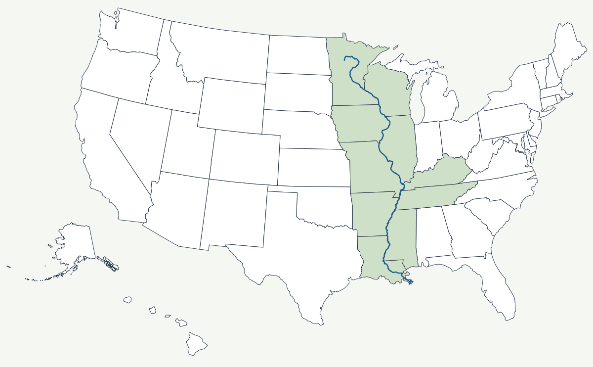
The Mississippi starts as a stream you can wade across at the outlet of Lake Itasca in northern Minnesota, about 1,475 feet above sea level, and ends in a bird's-foot delta of mud built out into the Gulf of Mexico. Between those two points it collects the Missouri, the Ohio, the Arkansas and the Red, and drains roughly 41 percent of the contiguous United States.
Which states does the Mississippi River touch?
Ten states have Mississippi River frontage. The river runs south through Minnesota past the Twin Cities, then becomes the boundary between Wisconsin and Iowa on the west and Illinois on the east. Below the Missouri confluence it separates Missouri from Illinois. Past the Ohio confluence the west bank is Missouri, then Arkansas, then Louisiana; the east bank opposite them is Kentucky, then Tennessee, then the state of Mississippi. Only in Minnesota and Louisiana does the river run through a state rather than along its edge.
| Source | Lake Itasca, Minnesota — about 1,475 ft above sea level |
| Mouth | Gulf of Mexico, about 100 river miles below New Orleans |
| Length | about 2,340 miles by the most-cited modern survey; older and longer figures are still quoted, because meander cutoffs keep shortening the channel and the mouth can be measured in more than one place |
| Drainage basin | about 1.2 million square miles — roughly 41% of the contiguous US, parts of 31 states and two Canadian provinces |
| States on its banks | 10 |
| Largest tributaries | Missouri, Ohio, Arkansas, Red |
| Only natural waterfall | St. Anthony Falls, Minneapolis |
Cities on the Mississippi
Minneapolis and St. Paul grew at St. Anthony Falls, the single break in the river's descent and the water power that made Minneapolis a flour-milling town. St. Louis sits a few miles below the Missouri confluence, at the point where the two largest rivers of the interior combine. Memphis stands on the Chickasaw Bluffs, one of the few stretches of high ground on the lower river's east bank and the reason a city could be built there at all. New Orleans occupies a crescent bend near the end, with parts of the city below sea level and the river held in place by levees.
How the river drew ten state lines
The 1783 treaty that ended the Revolution made the Mississippi the western boundary of the United States, and the Louisiana Purchase of 1803 bought the far bank. Every state admitted along it took the river as a border, which is why the middle of the country is divided by a line that wanders. Because those borders were fixed to the channel as it ran on a particular date, later meander cutoffs stranded land on the wrong side: pieces of Kentucky sit west of the river, and Kaskaskia, Illinois — the state's first capital — has been on the Missouri bank since a flood moved the channel in 1881. Upstream of Baton Rouge, near Simmesport, the Old River Control Structure holds the river in its present course; without it the Mississippi would long since have switched into the shorter, steeper Atchafalaya.
The system continues upstream and down: the Missouri side of the story is told on the Missouri River map, the eastern half on the Ohio River map, and the western tributary on the Arkansas River map. Where the river finally arrives is covered by the Gulf Coast map. For the whole picture, see the physical geography of the United States or the state page for Louisiana.