US Map / Geography / Missouri River
Missouri River Map
Six federal dams built between the 1930s and the 1960s turned hundreds of miles of the Missouri into reservoir.
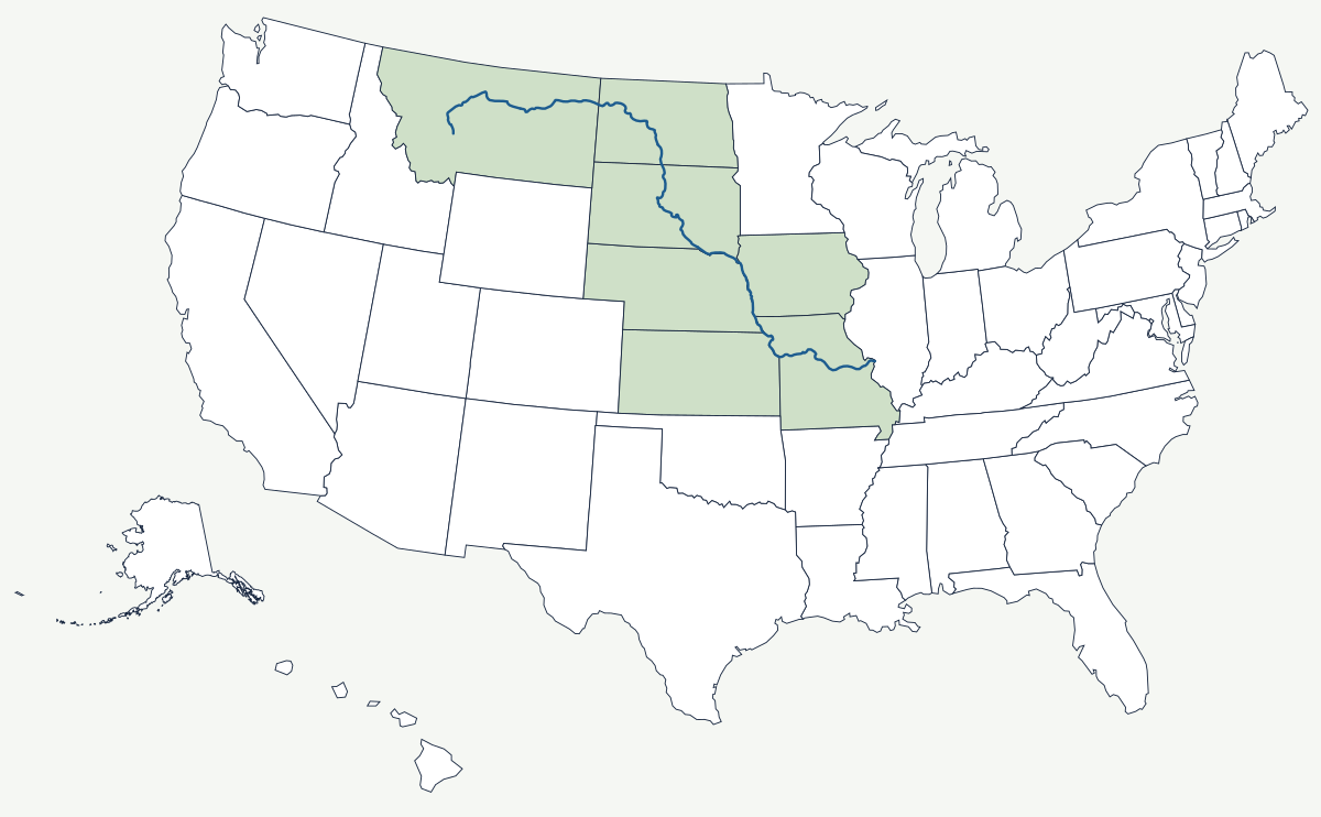
The Missouri begins at Three Forks, Montana, where the Jefferson, Madison and Gallatin rivers meet, and ends fifteen miles above St. Louis in the Mississippi. Along the way it drains about a sixth of the contiguous United States, most of it short-grass plains that send very little water per square mile.
Which states does the Missouri River cross?
Seven states. From Three Forks the river runs north and east across Montana, crosses North Dakota through Lake Sakakawea, and turns south through South Dakota. It then forms the line between South Dakota and Nebraska, between Nebraska and Iowa, and between Nebraska and Missouri, before separating Kansas from Missouri for a short reach north of Kansas City. The last 380-odd miles run diagonally across Missouri itself.
| Source | Three Forks, Montana — confluence of the Jefferson, Madison and Gallatin |
| Mouth | Mississippi River just above St. Louis |
| Length | about 2,340 miles by recent measurement; the long-standing USGS figure is 2,540 miles, which is why the Missouri is usually called the longest river in North America |
| Drainage basin | about 530,000 square miles, roughly one-sixth of the contiguous US |
| States crossed or bordered | Montana, North Dakota, South Dakota, Nebraska, Iowa, Kansas, Missouri |
| Main-stem dams | six, built under the 1944 Pick-Sloan plan: Fort Peck, Garrison, Oahe, Big Bend, Fort Randall, Gavins Point |
| Historic nickname | the Big Muddy, for the silt load it carried before the dams |
Cities on the Missouri
Omaha faces Council Bluffs across the river at the point the Union Pacific chose to begin building west in 1863; the crossing, not the site, made the city. Kansas City sits at the mouth of the Kansas River on the great bend where the Missouri stops running east and turns north, which put it at the natural jumping-off point for the Santa Fe and Oregon trails. St. Louis lies just below the confluence and was the outfitting town for the fur trade that worked its way up the whole river after Lewis and Clark rowed and poled the same route between 1804 and 1806.
How the river fixed borders and then moved
Four state lines follow the Missouri, and each has needed lawyers. Because the boundary is the channel and the channel is unstable, land has repeatedly changed sides: Carter Lake, Iowa, sits on the Nebraska bank because the river cut across a meander in 1877, and the Supreme Court had to decide in 1892 that a sudden avulsion does not move a state line while gradual accretion does. Upstream, the six main-stem dams replaced a shallow braided river with a chain of reservoirs, ended the annual floods that had built the bottomland, and drowned large parts of the Fort Berthold, Standing Rock and Cheyenne River reservations. Below Sioux City the channel was narrowed and stabilised for barge navigation, which is why the lower river runs fast and straight compared with the maps Lewis and Clark drew.
Downstream the water joins the Mississippi River; upstream it comes off the Rocky Mountains just east of the Continental Divide, and almost the whole basin lies within the Great Plains. See the physical geography of the United States for the rest of the system, or the state pages for Montana and Nebraska.