US Map / Geography / Arkansas River
Arkansas River Map
For thirty years the Arkansas River was the southwestern border of the United States.
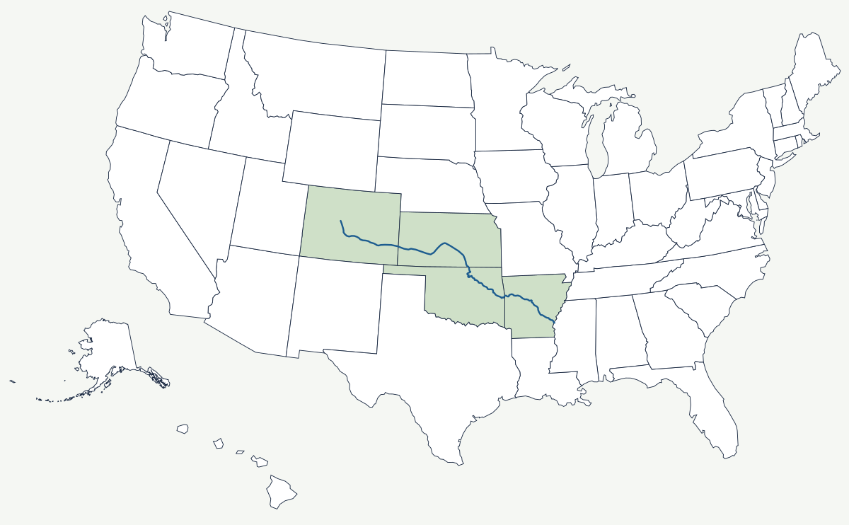
The Arkansas rises above 10,000 feet near Leadville, Colorado, in the Sawatch Range, and joins the Mississippi in the southeast corner of the state that shares its name, about 1,460 miles later. Almost all of its fall happens in the first 150 miles; after Cañon City it is a plains river, wide and shallow and heavily diverted, and in dry years stretches of it in Kansas carry no water at all.
Which states does the Arkansas River cross?
Four. It runs down the mountain valley from Leadville through the Royal Gorge to Pueblo, Colorado, then east onto the plains and into Kansas, where it makes a great bend south through Dodge City and back northeast through Wichita. It enters Oklahoma in the northeast corner of the state, passes Tulsa and Muskogee, and crosses into Arkansas at Fort Smith. The last reach runs southeast past Little Rock and Pine Bluff to the Mississippi. Two more states, New Mexico and Texas, drain into it through the Cimarron and the Canadian without touching the main stem.
| Source | Sawatch Range near Leadville, Colorado — above 10,000 feet |
| Mouth | Mississippi River in southeast Arkansas |
| Length | about 1,460 miles; published figures differ by a few dozen miles depending on where the channelised lower reach is measured |
| Drainage basin | about 170,000 square miles |
| States on the main stem | Colorado, Kansas, Oklahoma, Arkansas |
| Royal Gorge | a granite canyon near Cañon City; the suspension bridge hangs 955 feet above the water |
| Navigation | the McClellan-Kerr system, opened in 1971, carries barges 445 miles from the Mississippi to the Port of Catoosa near Tulsa |
Notable places along the river
The Royal Gorge is the river's most abrupt work: a slot cut in granite so narrow that the railroad and a rival company fought an armed dispute in 1878 over which of them could lay track along the floor. Out on the plains the river became the Santa Fe Trail's guide rail — the Mountain Route followed it to Bent's Fort in southeastern Colorado, and the Cimarron Cutoff left it near Dodge City to gamble on a shorter, drier crossing. Wichita grew where the Chisholm Trail crossed the Arkansas, and Tulsa sits at a shallow ford used by the Creek Nation after removal. Colorado Springs is not on the river but drains to it through Fountain Creek at Pueblo. In Kansas the name is stressed differently from the state's: locals say ar-KAN-zas.
How the river drew a border and then a barge channel
The Adams-Onís Treaty of 1819 fixed the boundary between the United States and Spanish territory along the Arkansas River from the 100th meridian to its source, and then north. For the next three decades everything south of the channel in what is now Colorado was Spanish and then Mexican soil, while the north bank was American, and Bent's Fort did business with both sides. The Mexican Cession of 1848 erased the line, but its ghost survives in the way the southern Colorado counties were laid out. The modern river is defined instead by engineering: the McClellan-Kerr Arkansas River Navigation System, completed in 1971, turned 445 miles of the lower river into a staircase of locks reaching from the Mississippi to a port on the outskirts of Tulsa, making landlocked Oklahoma a barge state. Upstream, irrigation in Colorado and Kansas consumes so much of the flow that the two states have litigated their compact repeatedly.
The Arkansas is one of the four great tributaries of the Mississippi River, alongside the Missouri. It falls off the Rocky Mountains, crosses the Great Plains, and passes the southern edge of the Ozarks in its last hundred miles. See the physical geography of the United States, or the state pages for Arkansas and Oklahoma.