US Map / Geography / Ohio River
Ohio River Map
At the junction with the Mississippi the Ohio is the larger river, and has been since long before anyone measured it.
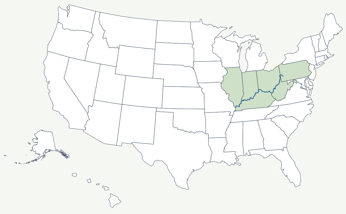
The Ohio does not have a source in the usual sense. It begins at the Point in Pittsburgh, where the Allegheny arrives from the north and the Monongahela from the south, and runs 981 miles to Cairo, Illinois, where it meets the Mississippi carrying more water than the Mississippi itself. Everything about the settlement of the interior followed from that: a wide, navigable river pointing west, starting at the far edge of the Appalachian coalfield.
Which states does the Ohio River cross?
Six. The first forty-odd miles are inside Pennsylvania, from Pittsburgh down past Beaver. At the northern panhandle the river reaches the corner where Pennsylvania, Ohio and West Virginia meet, and from there it separates Ohio from West Virginia past Wheeling and Huntington. Below the Big Sandy it becomes the Ohio–Kentucky line, running past Cincinnati. West of the Indiana corner it divides Indiana from Kentucky, and for the last stretch above the mouth it divides Illinois from Kentucky. Only in Pennsylvania is the river entirely within one state.
| Head | Pittsburgh, Pennsylvania — confluence of the Allegheny and Monongahela |
| Mouth | Mississippi River at Cairo, Illinois |
| Length | 981 miles |
| Drainage basin | about 189,000 square miles across fourteen states |
| States on its banks | Pennsylvania, Ohio, West Virginia, Kentucky, Indiana, Illinois |
| Largest tributary | the Tennessee River, which joins at Paducah, Kentucky |
| Only natural obstruction | the Falls of the Ohio at Louisville — a limestone rapids dropping about 26 feet in two miles |
| Boundary line | the low-water mark on the northern bank as it stood in 1792, which puts nearly the whole river in Kentucky |
Cities on the Ohio
Pittsburgh sits at the head of navigation, on the triangle of flat ground between the two rivers that make the third. Its steel industry existed because coal, coke and river barges met in the same place. Cincinnati grew on a bend where the north bank offers a broad terrace above flood level; it was the largest city in the West in the 1840s, and the Roebling suspension bridge that opened there in 1866 was the prototype for the Brooklyn Bridge. Louisville exists because of the Falls of the Ohio, the single place where the river drops over a limestone reef and boats had to stop. Cargo was unloaded, carried around and reloaded until the Louisville and Portland Canal opened in 1830; the modern McAlpine Locks do the same job on the same site.
How the Ohio became a boundary in two senses
The Northwest Ordinance of 1787 banned slavery in the territory north of the river, and Kentucky entered the Union in 1792 as a slave state. From then until the Civil War the Ohio was the line between free soil and slave soil for a thousand miles, and the towns on the northern bank — Ripley, Madison, New Albany — became crossing points on the Underground Railroad. The same 1792 cession produced the river's other oddity. Virginia kept the whole channel when it gave up Kentucky, so the boundary is not the middle of the river but the low-water mark on the northern bank as it stood that year. Kentucky therefore owns the water in front of Cincinnati and Evansville, and the Supreme Court has twice had to restate the rule as dams raised the pool above the historic mark. Navigation has been engineered ever since: a staircase of locks and dams holds a nine-foot channel the whole way, and the flood of January 1937, which put a fifth of Louisville under water, produced the reservoir system on the tributaries.
The river ends at the Mississippi and is fed by the Tennessee River; its headwaters drain the western slope of the Appalachian Mountains. See the physical geography of the United States, or the state pages for Ohio and Kentucky.