US Map / Geography / Rocky Mountains
Rocky Mountains Map
Every drop of rain that falls in the Rockies is sorted, within a few feet, toward either the Pacific or the Atlantic.
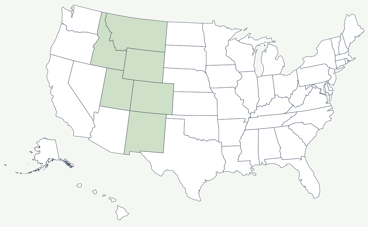
The Rockies run roughly 3,000 miles from northern New Mexico to northern British Columbia. The American portion is not one range but dozens — the Sangre de Cristo, the San Juan, the Sawatch, the Front Range, the Wind Rivers, the Bitterroots, the Sawtooths — separated by basins and parks large enough to hold their own weather. What ties them together is the Continental Divide, which threads through the whole system and decides which ocean the snowmelt reaches.
Which states do the Rocky Mountains cover?
Six. The southern end begins in New Mexico above Santa Fe with the Sangre de Cristo range, and widens through Colorado, which holds the highest and most extensive part. North of that the ranges split around the basins of Wyoming, reach west into the Uinta and Wasatch country of Utah, and continue through central Idaho and western Montana to the Canadian line at Glacier National Park. The line between the Rockies and the plains is unusually sharp: at Denver and Colorado Springs the Front Range stands straight up out of flat ground with no foothills worth the name.
| State | Highest peak | Elevation |
|---|---|---|
| Colorado | Mount Elbert | about 14,440 ft |
| Wyoming | Gannett Peak | 13,809 ft |
| Utah | Kings Peak | 13,528 ft |
| New Mexico | Wheeler Peak | 13,161 ft |
| Montana | Granite Peak | 12,799 ft |
| Idaho | Borah Peak | 12,662 ft |
Mount Elbert is the highest summit in the range and the second-highest in the contiguous United States after Mount Whitney. Its published elevation has moved slightly as surveys were redone — older maps give 14,433 feet, newer ones about 14,440 — and the same is true of most Colorado summits. Colorado alone has more than fifty peaks above 14,000 feet, though the exact count depends on how much drop between summits you insist on before calling something a separate mountain.
The passes, and why they decided the map
A wall this high is defined by its gaps. South Pass in Wyoming, at about 7,400 feet, is so broad and so gently graded that wagons crossed the Continental Divide there without realising it, and the Oregon, California and Mormon trails all funnelled through it. The first transcontinental railroad went further south still, avoiding the high ranges by crossing the wide Wyoming Basin. Later routes had to fight for their gaps: the Moffat Tunnel bores under the Front Range crest west of Denver, and the Eisenhower Tunnel carries Interstate 70 through the divide at about 11,150 feet, the highest point on the Interstate system. Trail Ridge Road in Rocky Mountain National Park climbs above 12,000 feet and closes with the first heavy snow.
How the range shaped settlement
Nothing about Rocky Mountain settlement follows farmland. The 1859 Pikes Peak rush put Denver at the mouth of Cherry Creek before there was any reason for a city there; silver built Leadville at 10,000 feet; copper built Butte, Montana, on top of its own ore body. Towns appeared at deposits and passes and disappeared when the ore ran out, which is why the interior West has ghost towns rather than abandoned farms. The ranges also decide where the water is: snowpack here supplies the Colorado, the Rio Grande, the Missouri, the Snake and the Arkansas, so states hundreds of miles away litigate over what falls on these slopes. Federal ownership follows the same logic — the high country was too steep to homestead, so it stayed public, and national forest and park land covers most of the range.
The spine of the range is described on the Continental Divide page, and its eastern foot on the Great Plains page. Rivers that begin here have their own maps: the Colorado, the Missouri and the Arkansas. Further west lie the Sierra Nevada. See the physical geography of the United States, or the state pages for Colorado and Montana.