US Map / Geography / Colorado River
Colorado River Map
In most years the Colorado is used up before it reaches the sea.
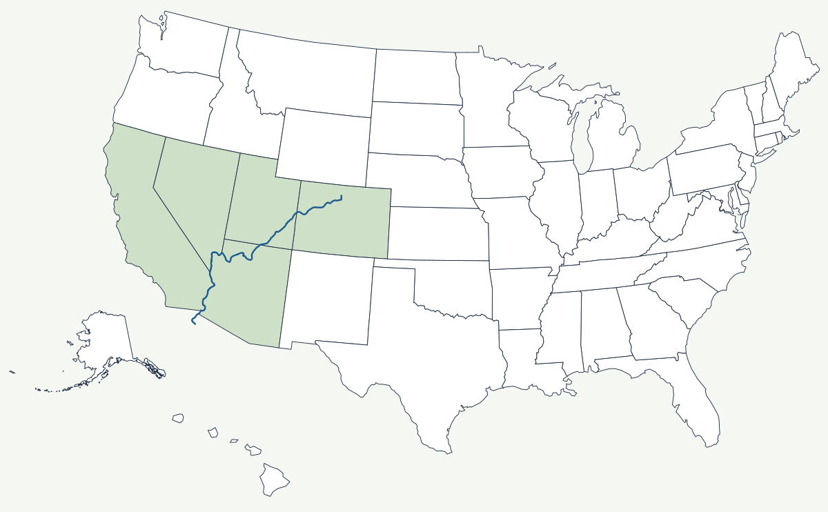
The Colorado rises at La Poudre Pass in Colorado, about 10,200 feet up in Rocky Mountain National Park, and runs about 1,450 miles to a delta in Mexico it now rarely reaches. Snowmelt from a small, high part of the basin supplies water to roughly 40 million people and several million acres of irrigated farmland, which is the central fact about this river and the reason every mile of it is measured.
Which states does the Colorado River cross?
The main stem touches five. It flows west and south out of Colorado into Utah, where the Green River joins it in Canyonlands and the combined river enters Lake Powell. It crosses into Arizona for Glen Canyon and the Grand Canyon, then turns south: from Lake Mead down to Davis Dam it forms the Arizona–Nevada boundary, and from Davis Dam to the international line it separates Arizona from California. Two more states, Wyoming and New Mexico, drain into it through the Green and the San Juan without touching the main stem.
| Source | La Poudre Pass, Rocky Mountain National Park, Colorado — about 10,200 ft |
| Length | about 1,450 miles |
| Drainage basin | about 246,000 square miles across seven states |
| States on the main stem | Colorado, Utah, Arizona, Nevada, California, then Mexico |
| Grand Canyon reach | 277 river miles |
| Largest reservoirs | Lake Mead behind Hoover Dam; Lake Powell behind Glen Canyon Dam |
| Compact allocation | 7.5 million acre-feet a year to the Upper Basin and the same to the Lower Basin under the 1922 compact, plus 1.5 million to Mexico under a 1944 treaty |
Notable places along the river
The Grand Canyon is the river's best-known work: 277 miles of channel a mile below the rim, cut through rock that gets older the deeper you go. Hoover Dam, finished in 1936, backs up Lake Mead, the largest reservoir in the country by capacity and the source of most of the drinking water for Las Vegas and Henderson. Farther downstream the All-American Canal carries river water west into California's Imperial Valley, and the Central Arizona Project lifts it 336 miles uphill to Phoenix and Tucson — a canal finished in 1993 that made the desert cities of central Arizona river users despite sitting far from the river.
How the river was divided
The Colorado River Compact of 1922 split the basin at Lee Ferry, Arizona, and gave each half 7.5 million acre-feet a year. The negotiators used flow records from an unusually wet run of years, so the paper allocation has almost always exceeded the water actually in the channel, and the shortfall has been managed by argument, litigation and reservoir drawdown ever since. The Supreme Court's 1963 decree in Arizona v. California fixed the Lower Basin shares, and a 1944 treaty guarantees Mexico a delivery that in most years is consumed before the delta. The river also draws the map: it is the Arizona–California state line, and where the border was surveyed against a shifting channel, small parcels of each state ended up on the far bank.
The Colorado's headwaters lie in the Rocky Mountains just west of the Continental Divide, and its lower course cuts the eastern edge of the Mojave Desert. The Southwest's other great river is the Rio Grande. See the physical geography of the United States, or the state pages for Arizona and Nevada.