US Map / County Maps / Wyoming
Wyoming County Map
Wyoming's first five counties were strips running the whole height of the territory, drawn along the Union Pacific track in 1867.
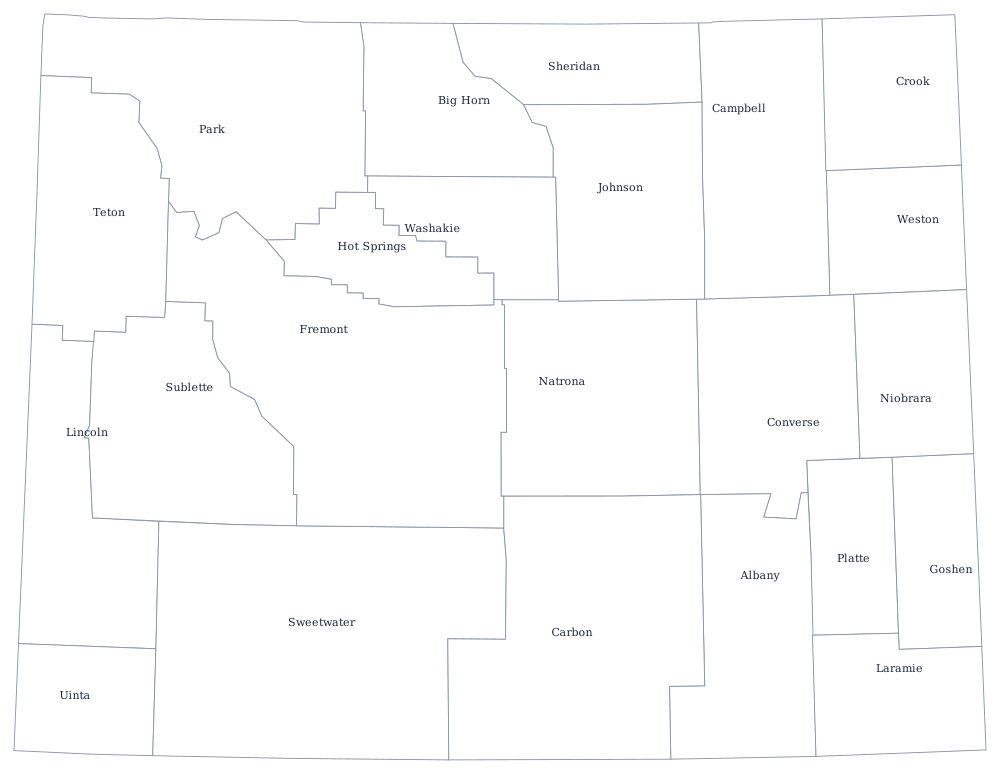

The Union Pacific reached Cheyenne in 1867, before Wyoming Territory existed, and the first counties were drawn to give every stretch of the track a courthouse: Laramie, Albany, Carbon, Sweetwater, and Uinta, five strips each running from the Colorado line north to Montana. Everything since has been horizontal subdivision, and the last two, Sublette and Teton, were both created in 1921 out of the north-west.
The 23 counties of Wyoming
Wyoming is the least populous state, and its county table shows it: no county reaches 110,000, and the largest, Laramie County, would be a middling suburb anywhere else. The ten below hold 78% of the state.
| County | County seat | Population (2024 estimate) |
|---|---|---|
| Laramie County | Cheyenne | 101,783 |
| Natrona County | Casper | 80,410 |
| Campbell County | Gillette | 47,946 |
| Sweetwater County | Green River | 41,273 |
| Fremont County | Lander | 39,721 |
| Albany County | Laramie | 39,288 |
| Sheridan County | Sheridan | 32,978 |
| Park County | Cody | 31,082 |
| Teton County | Jackson | 23,272 |
| Lincoln County | Kemmerer | 21,000 |
Counties that live on minerals
Wyoming has no income tax and unusually low property taxes on homes, and the reason is underground. Coal, oil, gas, trona, and uranium are assessed and taxed at the county level as production occurs, so a county with a large mine has a tax base out of all proportion to its population. Campbell County produces more coal than any other county in the United States — the Powder River Basin mines there have supplied a large share of the country's thermal coal for decades — and its assessed valuation has at times exceeded that of counties ten times its size. When coal or gas prices fall, county budgets and school funding fall with them, which is why Wyoming built a state school foundation formula that redistributes mineral money from the producing counties to the rest.
Government itself is minimal: three commissioners, elected at large, plus a sheriff, clerk, treasurer, assessor, coroner, county attorney, and clerk of district court. Wyoming has no township layer at all, so outside the incorporated towns the county is the only local government. Teton County is the outlier in every direction — most of it is Grand Teton National Park and Bridger-Teton National Forest, it has the highest per-capita income of any county in the United States, and it is the only Wyoming county where housing rather than minerals drives the assessment roll.
Largest and smallest counties
Laramie County, which contains Cheyenne and the state capital, is the most populous at 101,783 in the 2024 estimates, ahead of Natrona County, which is Casper, at 80,410. The smallest is Niobrara County in the north-east corner, 2,301 people, with a courthouse at Lusk — one of the least populous counties in the country. Sweetwater County, in the south-west desert, is the largest by land area at roughly 10,420 square miles, bigger than Maryland.
See the Wyoming state page for the ranges and the basins, or the county map index for the other 49 states. Bordering county maps: Montana, South Dakota, Nebraska, Colorado, and Utah. The Rocky Mountains page covers the ranges that keep the western counties empty.