US Map / County Maps / Montana
Montana County Map
Montana created 28 counties in fifteen years, and the homestead boom that paid for them collapsed almost immediately afterwards.
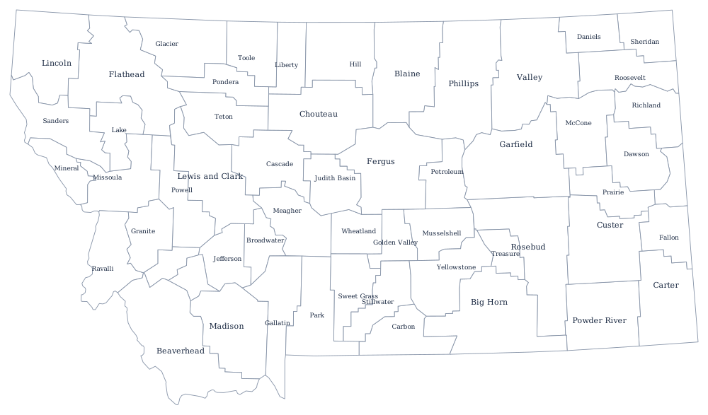
Montana Territory began in 1864 with nine counties, some of them the size of small countries. The map stayed roughly that way until the dryland homestead rush after 1909, when the Enlarged Homestead Act and a run of wet years brought tens of thousands of farmers onto the eastern plains. Every new cluster of homesteads wanted a courthouse within reach, and the legislature obliged: 56 counties by 1925, and none created since.
The 56 counties of Montana
Montana has no city over 120,000, so the county table is flatter than most: the largest county holds only 15% of the state, and the ten together come to 73%.
| County | County seat | Population (2024 estimate) |
|---|---|---|
| Yellowstone County | Billings | 171,583 |
| Gallatin County | Bozeman | 126,984 |
| Missoula County | Missoula | 122,546 |
| Flathead County | Kalispell | 114,527 |
| Cascade County | Great Falls | 84,523 |
| Lewis and Clark County | Helena | 75,129 |
| Ravalli County | Hamilton | 48,187 |
| Silver Bow County | Butte | 36,134 |
| Lake County | Polson | 33,403 |
| Lincoln County | Libby | 22,184 |
The county-splitting boom, and the bust that followed
The 1911 Leighton Act let residents force a county division by petition and referendum, and a promoter named Dan McKay made a business of running those campaigns across eastern Montana, town by town. The pitch was simple: a courthouse of your own means a county seat, a land office, and land values. Counties were split, then split again, and several of the new ones bonded themselves heavily to build courthouses. Then the rain stopped. Drought from 1917, followed by the collapse of wartime wheat prices, emptied the plains — half the homesteaders in eastern Montana left in the 1920s — and left counties with 2,000 residents paying off courthouses built for 10,000.
Most of them are still there. Montana counties are run by three commissioners, and Butte and Anaconda took the other path: Butte merged with Silver Bow County in 1977 and Anaconda with Deer Lodge County the same year, giving the state two consolidated city-counties. Petroleum County, created in 1925 and now the least populous, was among the last of the splits and has never had more than about 2,000 people.
Largest and smallest counties
Yellowstone County, which contains Billings, is the most populous at 171,583 in the 2024 estimates, ahead of Gallatin County at 126,984 — Bozeman and the Gallatin Valley, the fastest-growing part of the state. The smallest is Petroleum County, 525 people around Winnett, one of the least populous counties in the United States. Beaverhead County in the south-west is the largest by land area at about 5,540 square miles, bigger than Connecticut.
The Montana state page covers the ranges and the rivers, and the county map index covers the other 49. Bordering county maps: Idaho, Wyoming, North Dakota, and South Dakota. The Continental Divide page follows the line that splits the state's county map into mountain and plain.