US Map / County Maps / South Dakota
South Dakota County Map
Two South Dakota counties have no county government of their own; they are attached to a neighbor for everything a courthouse does.
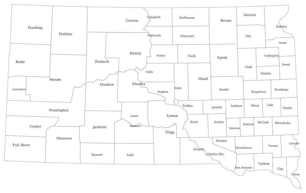
South Dakotans divide their state into East River and West River, and the county map makes the split obvious. East of the Missouri the counties were laid out during the Dakota boom of the 1880s for a farm economy and are mostly twenty-four miles square. West of it the counties were drawn later and much larger, over range country and over the Great Sioux Reservation, which Congress broke up in 1889.
The 66 counties of South Dakota
Minnehaha and Lincoln are Sioux Falls and its suburbs; Pennington is Rapid City. Those three hold 43% of the state. The ten below reach 66%.
| County | County seat | Population (2024 estimate) |
|---|---|---|
| Minnehaha County | Sioux Falls | 208,639 |
| Pennington County | Rapid City | 115,979 |
| Lincoln County | Canton | 75,244 |
| Brown County | Aberdeen | 37,495 |
| Brookings County | Brookings | 36,359 |
| Meade County | Sturgis | 30,918 |
| Codington County | Watertown | 29,278 |
| Lawrence County | Deadwood | 28,809 |
| Yankton County | Yankton | 23,509 |
| Davison County | Mitchell | 19,907 |
Unorganized counties, and the reservations they sit on
Oglala Lakota County and Todd County are counties without county governments. Both lie entirely inside Indian reservations — Pine Ridge and Rosebud — and neither was ever organized, so each is attached to a neighbor for administration: Oglala Lakota to Fall River County, Todd to Tripp County. Residents vote for the officers of the county that administers theirs, and court records and deeds are kept in Hot Springs and Winner rather than in Kyle or Mission. Oglala Lakota County was called Shannon County until 2015, when its voters chose the new name; it is consistently among the lowest-income counties in the country.
The rest are conventional: three or five commissioners, an auditor, treasurer, sheriff, register of deeds and state's attorney, and a courthouse in a town of a few thousand. Many West River counties are so thinly settled and so largely trust land that the taxable base is small; several share a state's attorney or a highway superintendent with neighbors. Jones, Harding, and Hyde counties each have fewer than 1,400 residents.
Largest and smallest counties
Minnehaha County is the most populous at 208,639 in the 2024 estimates, 23% of the state, and contains Sioux Falls; Pennington County is second at 115,979 and contains Rapid City. The smallest is Jones County in the center of the state, 874 people, with its courthouse at Murdo. Meade County, which runs from Sturgis east across the plains, is the largest by land area at about 3,470 square miles — bigger than Delaware and Rhode Island together.
The South Dakota state page has the Black Hills and the prairie, and the county map index has the whole country. Bordering county maps: North Dakota, Minnesota, Iowa, Nebraska, and Wyoming. The Missouri River page follows the divide between East River and West River.