US Map / County Maps / Utah
Utah County Map
Utah's counties were laid out valley by valley from 1850, and the thing being divided was not land but water.
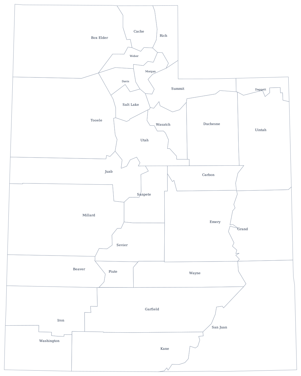
The provisional State of Deseret created Utah's first counties in 1850, and the logic was irrigation. A Mormon settlement needed a canyon stream, so counties were drawn as strips reaching from the valley floor up into the Wasatch to capture a whole drainage — Salt Lake, Davis, Weber, Utah, and Cache counties all have that shape. The desert counties east and south, where there was no water to divide, were left large and were organized much later.
The 29 counties of Utah
Utah is one of the most concentrated states in the country: Salt Lake, Utah and Davis counties hold 67% of it between them, and the ten below come to 92%.
| County | County seat | Population (2024 estimate) |
|---|---|---|
| Salt Lake County | Salt Lake City | 1,216,274 |
| Utah County | Provo | 747,234 |
| Davis County | Farmington | 378,470 |
| Weber County | Ogden | 276,118 |
| Washington County | St. George | 207,943 |
| Cache County | Logan | 145,487 |
| Tooele County | Tooele | 84,488 |
| Iron County | Parowan | 65,936 |
| Box Elder County | Brigham City | 64,120 |
| Summit County | Coalville | 43,109 |
Counties in a state that is mostly federal land
About two thirds of Utah is owned by the federal government — Bureau of Land Management rangeland, national forest, five national parks, and the Utah Test and Training Range — and none of it is taxable. In the southern counties the proportion is far higher: more than 90 per cent of Garfield County and Kane County is federal or state land. County budgets there rest on payments in lieu of taxes, a share of mineral lease revenue, and tourism, and the politics of national monument designations at Grand Staircase-Escalante and Bears Ears have been county politics as much as national ones.
Utah sorts its counties into classes by population, which determines the form of government available, and state law now lets counties choose among several structures: the traditional three-member commission that combines executive and legislative power, an expanded commission, or a council with a separately elected or appointed executive. Salt Lake County adopted a mayor-and-council form in 2000. San Juan County, where a majority of residents are Navajo, was ordered by a federal court in 2016 to redraw commission and school board districts that had been found to dilute Native voting strength.
Largest and smallest counties
Salt Lake County is the most populous at 1,216,274 in the 2024 estimates, 35% of the state, and contains Salt Lake City; Utah County is second at 747,234 and holds Provo and Orem. The smallest is Daggett County in the north-east corner, 956 people around Flaming Gorge, with a courthouse at Manila and no road connecting it to the rest of the state that does not leave Utah. San Juan County is the largest by land area at roughly 7,820 square miles.
See the Utah state page for the parks and the Wasatch Front, or the county map index for the other 49. Bordering county maps: Idaho, Wyoming, Colorado, Arizona, and Nevada. The Great Salt Lake page covers the water that five northern Utah counties share.