US Map / County Maps / Iowa
Iowa County Map
Iowa's 99 counties come closer to a perfect grid than any other state's, and the exceptions all have reasons.
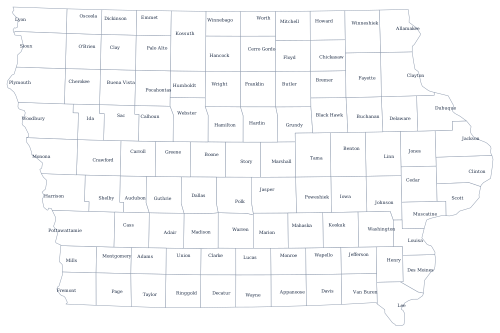
No state carries the Public Land Survey more plainly than Iowa. The whole state was surveyed from the Fifth Principal Meridian before it filled up, and the legislature laid counties out on paper in advance — often four townships by four, twenty-four miles on a side, whether or not anyone lived there yet. The last of the 99 was organized in 1857, and the pattern has not changed since; the seats were placed at or near the center of each county so that no farmer was more than a half-day's wagon ride from the courthouse.
The 99 counties of Iowa
The ten largest hold 53% of Iowans, and every one of them contains a city of at least 50,000. Polk County, which is Des Moines, is the only one over half a million.
| County | County seat | Population (2024 estimate) |
|---|---|---|
| Polk County | Des Moines | 516,185 |
| Linn County | Cedar Rapids | 231,762 |
| Scott County | Davenport | 175,601 |
| Johnson County | Iowa City | 160,080 |
| Black Hawk County | Waterloo | 132,348 |
| Dallas County | Adel | 115,343 |
| Woodbury County | Sioux City | 107,257 |
| Story County | Nevada | 102,498 |
| Dubuque County | Dubuque | 99,242 |
| Pottawattamie County | Council Bluffs | 93,529 |
Ninety-nine counties, and the ones that are emptying
Iowa's counties are governed by boards of supervisors, three members in most and five in the largest, plus the usual elected auditor, recorder, treasurer, sheriff and attorney. Because the counties were sized for horse travel and Iowa has been losing rural population since 1900, a great many of them now run a full courthouse for fewer than 8,000 people. Two thirds of the 99 counties have fewer residents today than they had in the 1900 census, and in the western tier several have less than half. The state has responded with shared services rather than mergers: counties combine emergency dispatch, contract for engineers, and run joint mental health regions, but no two Iowa counties have ever consolidated.
Kossuth County is the visible exception to the grid. It was extended north in the 1850s to absorb Bancroft County, which had been created on paper but never organized, and the resulting county is twice the height of its neighbors and the largest in the state. Elsewhere the anomalies are river-made: Lee County in the far south-east comes to a point at the confluence of the Des Moines and the Mississippi, and Fremont, Mills, and Pottawattamie counties in the west have boundaries the Missouri River moved.
Largest and smallest counties
Polk County, containing Des Moines and West Des Moines, is the most populous at 516,185 in 2024 — 16% of the state — and it is the only Iowa county whose population has grown by more than 100,000 this century. Linn County, which is Cedar Rapids, is second at 231,762. The smallest is Adams County in the south-west, 3,606 people, with a courthouse in Corning. Kossuth County is the largest by land area at about 973 square miles.
Up a level: the Iowa state page and the county map index. County maps of the neighbors: Minnesota, Wisconsin, Illinois, Missouri, and Nebraska. The Missouri River page follows the western boundary and the shifts that redrew it.