US Map / County Maps / Oklahoma
Oklahoma County Map
Half of Oklahoma's counties began as lettered districts after a land run; the other half were drawn over the Indian Territory at statehood.
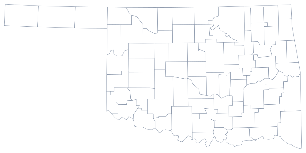
Two systems met here. When the Unassigned Lands were opened by the land run of 1889, the new Oklahoma Territory was divided into counties identified at first only by number and letter — First County through Seventh County, then County A onward — until residents voted on names. The eastern half of the future state was Indian Territory, governed by the Five Tribes and divided into recording districts rather than counties. The 1907 constitutional convention drew 75 counties across both and the number reached 77 soon after.
The 77 counties of Oklahoma
Oklahoma and Tulsa counties hold 44% of the state with Cleveland County between them. The ten below reach 62%.
| County | County seat | Population (2024 estimate) |
|---|---|---|
| Oklahoma County | Oklahoma City | 816,490 |
| Tulsa County | Tulsa | 693,514 |
| Cleveland County | Norman | 303,952 |
| Canadian County | El Reno | 181,760 |
| Comanche County | Lawton | 121,396 |
| Rogers County | Claremore | 101,371 |
| Wagoner County | Wagoner | 91,257 |
| Payne County | Stillwater | 84,199 |
| Pottawatomie County | Shawnee | 74,446 |
| Creek County | Sapulpa | 73,971 |
Osage County, the panhandle, and a commissioner for every road
Osage County is not like the others. Its boundaries are the boundaries of the Osage Nation reservation, unchanged since 1872, and beneath the whole county lies the Osage mineral estate — the tribe holds the oil and gas rights communally, no matter who owns the surface, an arrangement written into the 1906 allotment act and litigated ever since. It is also the largest county in the state by land area, about 2,250 square miles.
At the other end of the state, the panhandle counties were No Man's Land: a strip left outside every territory after Texas gave up its claim north of 36°30′ in 1850, unassigned to any government until Oklahoma Territory absorbed it in 1890. Cimarron County at the far end is the only county in the United States that touches four states — New Mexico, Colorado, Kansas, and Texas. Governing all 77 counties is a three-member board of county commissioners, each elected from a district and each traditionally responsible for the roads in that district, an arrangement that has repeatedly drawn the attention of federal prosecutors and was tightened after a county-purchasing scandal in the early 1980s.
Largest and smallest counties
Oklahoma County is the most populous at 816,490 in the 2024 estimates and contains Oklahoma City; Tulsa County is second at 693,514 and contains Tulsa. The smallest is Cimarron County at the western tip of the panhandle, 2,133 people in about 1,835 square miles, with its courthouse at Boise City — the county worst hit by the Dust Bowl and one that has never recovered its 1930 population.
The Oklahoma state page has the rest of the state, and the county map index has every other one. Bordering county maps: Texas, Arkansas, Kansas, and New Mexico. The Arkansas River page follows the water that runs across the middle of the state's county map.