US Map / County Maps / Kansas
Kansas County Map
Kansas laid out 105 counties in thirty years, and towns killed each other over which one would hold the courthouse.
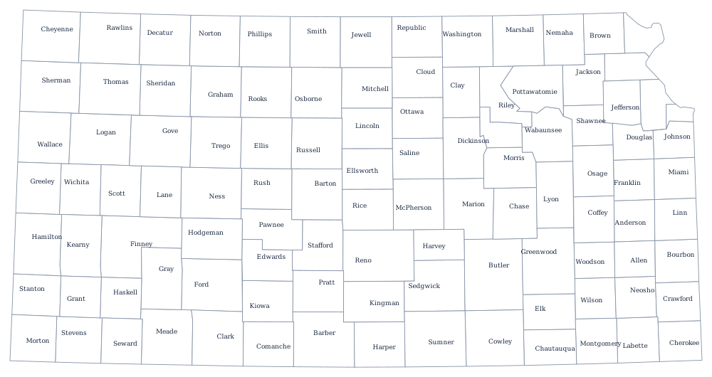

Kansas was organized in a hurry. The territory was opened in 1854, the eastern counties were created within months, and by 1888 the whole state had been divided into the 105 counties it still has. The western two thirds were drawn on paper first and settled afterwards, which is why they are so regular — thirty miles by thirty miles, four rows of them running to the Colorado line.
The 105 counties of Kansas
Johnson County, the Kansas half of metropolitan Kansas City, is the largest and has been since it passed Sedgwick in the 1980s. The ten counties below hold 67% of the state; the other 95 divide what is left.
| County | County seat | Population (2024 estimate) |
|---|---|---|
| Johnson County | Olathe | 632,276 |
| Sedgwick County | Wichita | 536,081 |
| Shawnee County | Topeka | 177,942 |
| Wyandotte County | Kansas City | 169,418 |
| Douglas County | Lawrence | 121,989 |
| Leavenworth County | Leavenworth | 84,670 |
| Riley County | Manhattan | 72,557 |
| Butler County | El Dorado | 69,158 |
| Reno County | Hutchinson | 61,417 |
| Saline County | Salina | 53,459 |
The county seat wars, and the counties that emptied
Being the county seat meant the courthouse, the land office, the lawyers, and usually the railroad, so in the 1880s western Kansas towns fought over the designation with stolen ballot boxes, imported voters, and occasionally gunfire. Stevens County's contest between Hugoton and Woodsdale ended in the Hay Meadow Massacre of 1888, in which the Hugoton sheriff and his party killed four Woodsdale men in No Man's Land. Similar fights emptied and moved county seats in Gray, Garfield, and Wichita counties. Garfield County lost outright — the state supreme court voided it in 1893 for being under the constitutional minimum size, and it was absorbed into Finney County.
The counties that won are now mostly shrinking. Kansas is governed at county level by three-member commissions in all but the largest, and more than half the 105 counties have fewer people today than in 1900. Wyandotte County took the other route: it merged with Kansas City, Kansas in 1997 to form a unified government with a single mayor and commission, the only consolidation of its kind in the state.
Largest and smallest counties
Johnson County in the Kansas City suburbs is the most populous at 632,276 in 2024, ahead of Sedgwick County, which is Wichita, at 536,081. The smallest is Greeley County on the Colorado line, 1,152 people in about 780 square miles, with its courthouse at Tribune. Butler County, east of Wichita, is the largest by land area at roughly 1,430 square miles.
See the Kansas state page for the rest, or the county map index. The county maps around it: Nebraska, Missouri, Oklahoma, and Colorado. The Great Plains page explains the rainfall line that separates the crowded eastern counties from the empty western ones.