US Map / County Maps / New Mexico
New Mexico County Map
New Mexico's first counties were laid out along the Rio Grande in 1852, and the river still carries much of the county map.
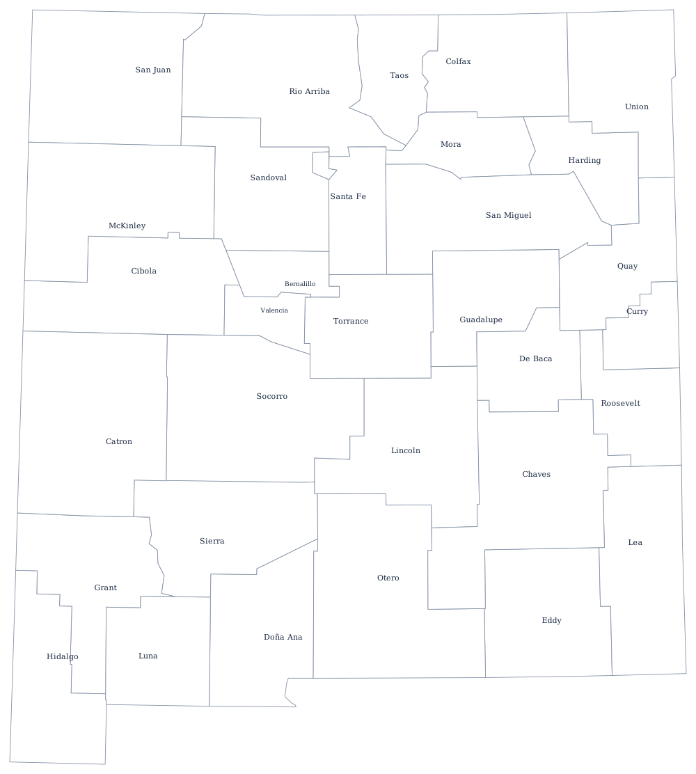

The territorial legislature's first act in 1852 divided New Mexico into nine counties, each of them a band across the Rio Grande valley anchored on an old Spanish villa — Santa Fe, Rio Arriba, Taos, Bernalillo, Valencia, Socorro, Doña Ana. The logic was water: every county needed a share of irrigable river bottom. As the eastern plains and the southern oilfields were settled after 1900 the strips were cut up into blocks, and the last county, Los Alamos, was created in 1949 around a laboratory that had not officially existed four years earlier.
The 33 counties of New Mexico
Bernalillo County, which is Albuquerque, holds 32% of the state on its own. The ten below reach 80%, and four of them are in the middle Rio Grande valley.
| County | County seat | Population (2024 estimate) |
|---|---|---|
| Bernalillo County | Albuquerque | 671,747 |
| Doña Ana County | Las Cruces | 229,366 |
| Santa Fe County | Santa Fe | 157,765 |
| Sandoval County | Bernalillo | 157,757 |
| San Juan County | Aztec | 120,817 |
| Valencia County | Los Lunas | 80,813 |
| Lea County | Lovington | 75,151 |
| Otero County | Alamogordo | 69,711 |
| McKinley County | Gallup | 68,945 |
| Chaves County | Roswell | 63,697 |
Land grants, reservations, and a county built for a laboratory
Much of New Mexico's land is held under titles older than the state. Spanish and Mexican community land grants — the ejidos and mercedes confirmed by the Treaty of Guadalupe Hidalgo — survive as land grant-mercedes, political subdivisions of the state with elected boards, and several counties in the north contain large areas the county does not tax or control. Add 23 sovereign tribal nations, including nineteen Pueblos, the Navajo Nation across the north-west, and the Mescalero and Jicarilla Apache reservations, and county government in New Mexico works around a great deal of land it does not govern. McKinley County is more than half tribal trust land.
Los Alamos County is the opposite case: a county created for a single federal installation. Split from Sandoval and Santa Fe counties in 1949, it is by far the smallest in area at about 109 square miles, it is a consolidated city-county, and its economy is one laboratory. Elsewhere counties are governed by three or five commissioners and rely on gross receipts tax rather than property tax, since New Mexico's property tax rates are among the lowest in the country.
Largest and smallest counties
Bernalillo County is the most populous at 671,747 in 2024 and contains Albuquerque; Doña Ana County is second at 229,366 around Las Cruces. The smallest is Harding County in the north-east, 635 people on shortgrass ranchland — one of the least populous counties in the United States, with a courthouse at Mosquero. Catron County in the west is the largest by land area at roughly 6,920 square miles, larger than Connecticut and Rhode Island together, with fewer than 4,000 residents.
The New Mexico state page covers the mountains and the desert; the county map index covers every state. Bordering county maps: Arizona, Colorado, Oklahoma, and Texas. The Rio Grande page follows the river the original nine counties were built around.