US Map / Geography / Snake River
Snake River Map
Hells Canyon, on the Idaho-Oregon line, is the deepest river gorge in North America.
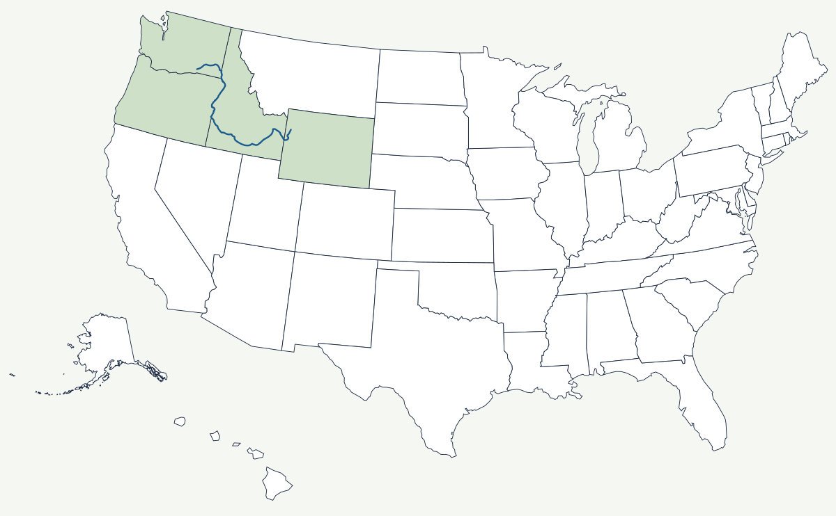
The Snake rises in the mountains of western Wyoming near the southern edge of Yellowstone, runs through Jackson Lake and Jackson Hole, and reaches the Columbia at Burbank, Washington, about 1,078 miles later. In between it crosses the whole width of Idaho in a long arc, drops over Shoshone Falls, and cuts Hells Canyon. It is the Columbia's largest tributary, and it carries the water that irrigates southern Idaho.
Which states does the Snake River cross?
Four on the main stem. From its headwaters in Wyoming the river enters Idaho near Palisades and swings west across the Snake River Plain past Idaho Falls, Twin Falls and the mouth of the Boise River. It then turns north and becomes the boundary between Idaho and Oregon for the whole of Hells Canyon — the northern part of that state line is the river, and only the southern part is a surveyed meridian. Below the canyon the Snake enters Washington at Lewiston and runs west to the Columbia. The basin reaches further still: the Owyhee brings water from northern Nevada, and a corner of Utah drains in through the Raft River.
| Source | western Wyoming, in the mountains south of Yellowstone |
| Mouth | Columbia River at Burbank, Washington |
| Length | about 1,078 miles |
| Drainage basin | about 108,000 square miles |
| States on the main stem | Wyoming, Idaho, Oregon, Washington |
| Hells Canyon | roughly 7,900 feet from the river up to He Devil Peak in the Seven Devils Mountains — the deepest river gorge in North America |
| Shoshone Falls | 212 feet — higher than Niagara, and the natural upstream limit for salmon and steelhead |
| Lower Snake dams | four: Ice Harbor, Lower Monumental, Little Goose, Lower Granite |
Notable places along the river
Shoshone Falls, just east of Twin Falls, is a 212-foot horseshoe cut into basalt. It was always the end of the line for migrating fish, which is why the salmon economies of the Columbia basin stopped there and the tribes above it lived differently from those below. The Snake River Plain that the falls sit in is a 400-mile arc of young lava flows — Craters of the Moon is the raw version of it — underlain by an aquifer that surfaces in the canyon walls at Thousand Springs. Hells Canyon, further north, is a mile and a half deep and has no road along its floor. At the canyon's foot the twin towns of Lewiston, Idaho, and Clarkston, Washington, face each other; the four lower Snake dams make Lewiston a working seaport for ocean-bound grain barges roughly 460 river miles from the Pacific. Boise, the largest city in the basin, sits on a tributary rather than the river itself.
How the Snake shaped Idaho
The Oregon Trail followed the Snake for hundreds of miles because there was no other dependable water across southern Idaho, and then left it because the canyon walls made the river useless for drinking or crossing. That pattern set the state's settlement: the towns line the plain, not the gorge. Irrigation changed the rest. Diversions beginning in the 1890s, and federal projects after the 1902 Reclamation Act, turned the sagebrush of the plain into the potato and sugar-beet country that still defines Idaho's economy, and the river is now allocated down to the acre-foot. The four lower dams, built between 1961 and 1975, added barge navigation and power at the cost of the salmon runs above them, and whether to breach them is the longest-running argument in Northwest water politics.
The Snake is the largest tributary of the Columbia River; its headwaters are in the Rocky Mountains close to the Continental Divide, and its lower canyon lies west of the Cascade Range rain shadow. See the physical geography of the United States, or the state pages for Idaho and Oregon.