US Map / County Maps / Alabama
Alabama County Map
Alabama's 67 counties were nearly all drawn before 1870, and the map still shows the cotton frontier that drew them.
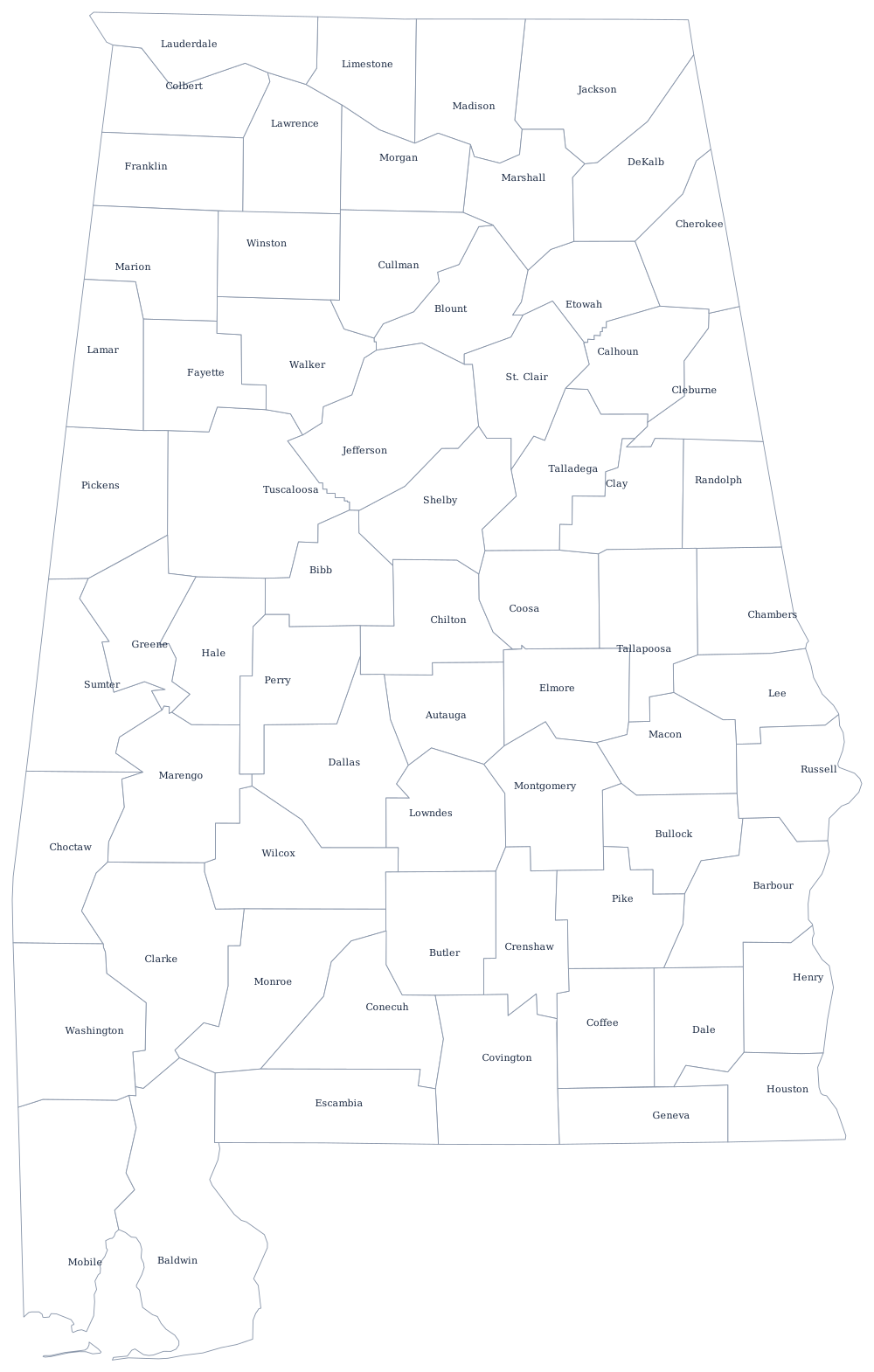
Alabama's county lines follow water more often than survey lines. The Tennessee River cuts the top of the state and separates the four northern counties from the rest; the Tombigbee, Alabama, and Chattahoochee rivers carry long stretches of interior boundary. Only in the southeast, where counties were laid out late on the Wiregrass plain, do the edges straighten into surveyed lines.
The 67 counties of Alabama
The ten most populous counties hold 56% of the state's people. Jefferson and Shelby are contiguous halves of metropolitan Birmingham; Madison is Huntsville, which has grown fast enough to pass Birmingham as the state's largest city.
| County | County seat | Population (2024 estimate) |
|---|---|---|
| Jefferson County | Birmingham | 664,744 |
| Madison County | Huntsville | 423,355 |
| Mobile County | Mobile | 412,339 |
| Baldwin County | Bay Minette | 261,608 |
| Tuscaloosa County | Tuscaloosa | 241,212 |
| Shelby County | Columbiana | 235,969 |
| Montgomery County | Montgomery | 225,894 |
| Lee County | Opelika | 187,847 |
| Morgan County | Decatur | 126,084 |
| Limestone County | Athens | 118,942 |
Why Alabama counties have to ask the legislature
Alabama gives its counties less independent authority than almost any other state. The 1901 constitution withheld home rule, so a county that wants to change a local tax, regulate a landfill, or set the salary of an office holder generally needs an act of the state legislature — and often a statewide constitutional amendment. That is the main reason the Alabama constitution is the longest in the world: most of its hundreds of amendments are local matters that any other state would settle at the courthouse.
The county commission runs each county, and in most of them the elected probate judge chairs it, an unusual blend of judicial and legislative roles. County seats were placed near the geographic center of each county so no citizen was more than a day's travel from the courthouse, which is why several seats — Bay Minette, Columbiana, Opelika — are much smaller than the biggest city in their own county.
Largest and smallest counties
Jefferson County is the largest, with 664,744 residents in the 2024 Census estimates, and it has been the state's population center since iron and steel built Birmingham in the 1870s. Greene County in the Black Belt is the smallest, at 7,127 — a county that had more people in 1900 than it does today. Baldwin County, on the eastern shore of Mobile Bay, is the largest by land area at roughly 1,590 square miles, bigger than the state of Rhode Island.
The Alabama state page sets these counties against the state's cities and rivers, and the county map index lists all 50 states. County maps of the neighbors: Mississippi, Tennessee, Georgia, and Florida. For labeling work, print the blank Alabama outline instead.