US Map / County Maps / Tennessee
Tennessee County Map
Tennessee's constitution divides the state into three grand divisions and requires a supreme court to sit in each — so the county map has three capitals of a sort.
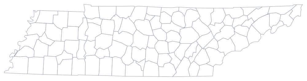
Tennessee's three grand divisions are not a figure of speech. They are defined in state law, the constitution requires the supreme court to sit in each of them — at Knoxville, Nashville, and Jackson — and appointments to many state boards must be balanced among them. The county map follows the same logic: the eastern counties were settled first from Virginia and North Carolina, Middle Tennessee filled after the Cumberland settlements of 1779, and the west was not opened until the Chickasaw cession of 1818.
The 95 counties of Tennessee
Shelby is Memphis and Davidson is Nashville; between them and Knox they hold 30% of the state. The ten below come to 55%, and four of them are the fast-growing suburban counties south and east of Nashville.
| County | County seat | Population (2024 estimate) |
|---|---|---|
| Shelby County | Memphis | 910,530 |
| Davidson County | Nashville | 729,505 |
| Knox County | Knoxville | 506,748 |
| Hamilton County | Chattanooga | 386,256 |
| Rutherford County | Murfreesboro | 376,996 |
| Williamson County | Franklin | 269,136 |
| Montgomery County | Clarksville | 246,025 |
| Sumner County | Gallatin | 211,721 |
| Wilson County | Lebanon | 169,948 |
| Sullivan County | Blountville | 162,703 |
Metropolitan government, and 95 county commissions
Nashville and Davidson County merged in 1963 to form the Metropolitan Government of Nashville and Davidson County — the first successful city-county consolidation in the South and the model that Jacksonville, Indianapolis, and Louisville later studied. It has a mayor, a 40-member metropolitan council, and two service districts with different tax rates, urban and general, so that farmland at the county's edge is not taxed for city services it does not receive. Two much smaller consolidations followed: Lynchburg with Moore County in 1988 and Hartsville with Trousdale County in 1988.
The other counties are run by a county mayor and a county commission, and each also elects a sheriff, trustee, register of deeds, county clerk, assessor, and highway superintendent. Tennessee has never had township government, so outside the incorporated cities the county is the only local authority, and its commission can be large — some counties elect more than twenty commissioners from small districts, a legacy of the old quarterly county court of justices of the peace it replaced in 1978.
Largest and smallest counties
Shelby County is the most populous at 910,530 in the 2024 estimates and contains Memphis; Davidson County is second at 729,505 and is the same territory as Nashville. The smallest is Pickett County on the Kentucky line in the Cumberland Plateau, 5,108 people, with a courthouse at Byrdstown. Shelby County is also the largest by land area, about 760 square miles.
Continue to the Tennessee state page or the county map index. Tennessee touches eight states, tying Missouri for the most; four of them are Kentucky, North Carolina, Georgia, and Mississippi. The Tennessee River page follows the water that crosses the state twice.