US Map / County Maps / Indiana
Indiana County Map
Indiana's 92 counties are among the most uniform in the country — and one of them stopped existing as a separate government in 1970.
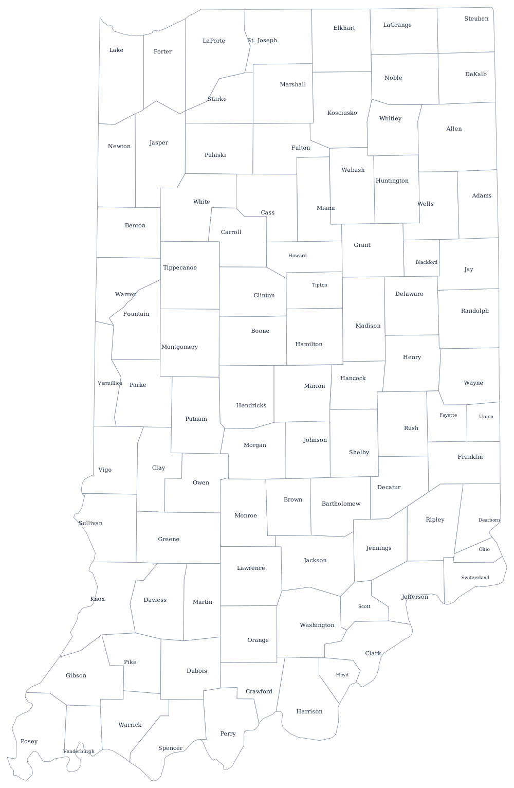
Indiana was the second state surveyed under the rectangular system, and it shows. The First Principal Meridian runs down the Ohio–Indiana line and the Second Principal Meridian runs through the middle of the state near Paoli; counties were assembled from whole survey townships against those axes between 1801 and 1859, mostly in blocks four to six townships square. Newton County, organized in 1859, was the last, and no Indiana county line has moved since.
The 92 counties of Indiana
Marion County is Indianapolis and holds 14% of the state; Hamilton County directly north of it has been the fastest-growing in Indiana for three decades. The ten largest together are 50% of Hoosiers.
| County | County seat | Population (2024 estimate) |
|---|---|---|
| Marion County | Indianapolis | 981,628 |
| Lake County | Crown Point | 502,955 |
| Allen County | Fort Wayne | 399,295 |
| Hamilton County | Noblesville | 379,704 |
| St. Joseph County | South Bend | 273,744 |
| Elkhart County | Goshen | 207,436 |
| Tippecanoe County | Lafayette | 191,650 |
| Hendricks County | Danville | 190,629 |
| Vanderburgh County | Evansville | 180,387 |
| Porter County | Valparaiso | 175,860 |
Unigov, and why Indianapolis is the same thing as Marion County
In 1969 the Indiana legislature passed Unigov, merging the city of Indianapolis with Marion County effective 1 January 1970. The mayor of Indianapolis became the executive of the county, and the City-County Council legislates for both. It was done without a referendum and it roughly tripled the city's population overnight, turning Indianapolis from a city hemmed in by suburbs into the largest city in the state by a wide margin. The merger was deliberately incomplete: Beech Grove, Lawrence, Southport and Speedway kept their own governments as included towns, and the school districts were left alone entirely, which is why Indianapolis Public Schools covers only part of the city.
The other 91 counties are ordinary. Three commissioners hold the executive and some legislative power, while a seven-member county council controls the budget and the tax rate — a split between spending and appropriating that is unusual and that Indiana has kept since 1899. Below them, townships survive as the smallest general-purpose government in the state, running poor relief, cemeteries, and in many rural areas the fire department.
Largest and smallest counties
Marion County is the most populous at 981,628 in 2024 and is the same territory as Indianapolis. Lake County, at the top of the state in the steel and refinery country of the Calumet, is second at 502,955, and Allen County is Fort Wayne at 399,295. The smallest is Ohio County, 5,996 people on the Ohio River — the smallest county by land area in Indiana at about 86 square miles, and one of the smallest in the country. Allen County is the largest by land area, roughly 657 square miles.
Continue to the Indiana state page or the county map index. The neighbors: Illinois, Michigan, Ohio, and Kentucky across the river. The Ohio River page explains the southern boundary, which sits at the far bank rather than mid-channel.