US Map / County Maps / North Carolina
North Carolina County Map
North Carolina has exactly 100 counties, and it has had exactly 100 since 1911.
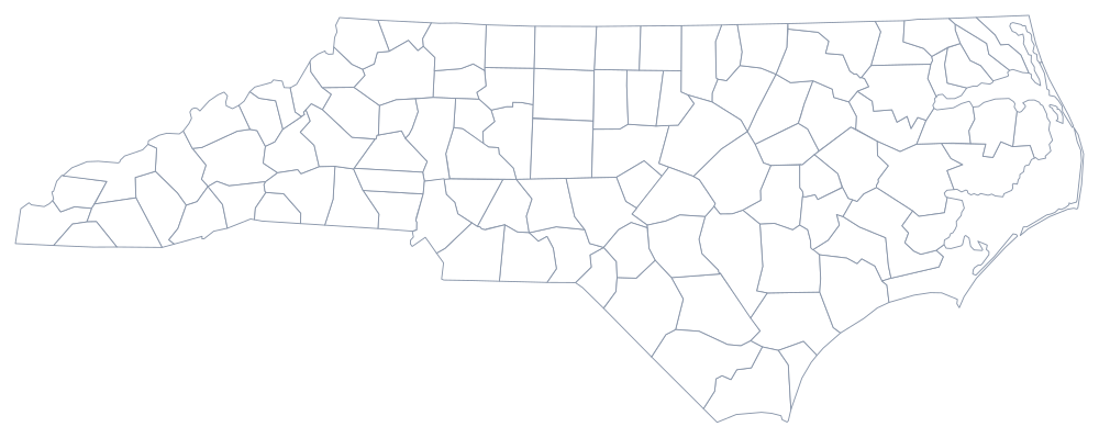
North Carolina reached 100 counties in 1911 with the creation of Avery and Hoke, and the number has not moved since — a tidy total that the state has made something of a habit of citing. The eastern counties are the oldest, laid out from the 1660s along the sounds and the tidal rivers; the mountain counties are the newest, several of them cut in the nineteenth century out of terrain that made a day's ride to the courthouse impossible.
The 100 counties of North Carolina
Wake and Mecklenburg — Raleigh and Charlotte — are almost the same size and between them hold more than a fifth of the state. The ten below come to 46% of North Carolinians.
| County | County seat | Population (2024 estimate) |
|---|---|---|
| Wake County | Raleigh | 1,232,444 |
| Mecklenburg County | Charlotte | 1,206,285 |
| Guilford County | Greensboro | 558,816 |
| Forsyth County | Winston-Salem | 398,143 |
| Durham County | Durham | 343,628 |
| Cumberland County | Fayetteville | 338,430 |
| Buncombe County | Asheville | 279,210 |
| Union County | Monroe | 263,386 |
| Johnston County | Smithfield | 249,794 |
| Cabarrus County | Concord | 244,925 |
One hundred counties that do not build roads
North Carolina counties are unusual in what they do not do. In 1931, in the middle of the Depression, the state took over every county road in North Carolina, and it has kept them: the Department of Transportation maintains close to 80,000 miles of highway, the second-largest state-maintained system in the country, and a North Carolina county has no road department at all. The same era shifted much of school funding to the state. What is left to the county is substantial anyway — public health, social services, emergency medical services, the register of deeds, the jail, land use outside the towns, and the capital cost of school buildings.
Each county is run by a board of commissioners, and the sheriff and register of deeds are separately elected. Because the state constitution requires uniform county government, North Carolina has no charter counties, no consolidated city-counties, and no elected county executives; a professional county manager, hired by the board, runs the administration in all 100. Townships still exist on paper as survey and voting divisions but have had no government since 1895.
Largest and smallest counties
Wake County, which contains Raleigh and part of Durham, is the most populous at 1,232,444 in the 2024 estimates, just ahead of Mecklenburg County at 1,206,285, which is Charlotte. Guilford County contains Greensboro and Forsyth County Winston-Salem. The smallest is Tyrrell County on the Albemarle Sound, 3,517 people, the least populous county in the state and one that is more than a third open water. Robeson and Sampson counties in the south-east are the largest by land area, each about 945 square miles.
See the North Carolina state page for the coast and the mountains, or the county map index for the whole country. The neighbors: Virginia, Tennessee, Georgia, and South Carolina. The Great Smoky Mountains page covers the western county line, which follows the crest.