US Map / County Maps / Massachusetts
Massachusetts County Map
Massachusetts has 14 counties and six county governments; the legislature abolished the other eight between 1997 and 2000.
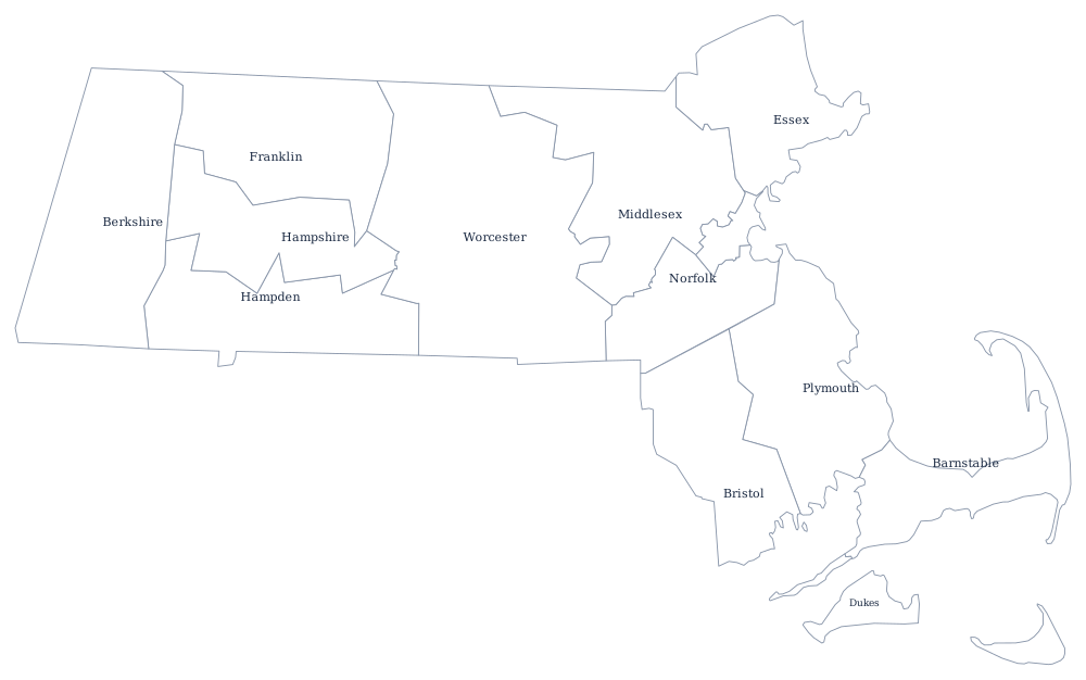
The counties were laid out between 1643 and 1811 and functioned for three centuries, but in Massachusetts the town has always been the real unit of government. All 351 cities and towns cover the entire state with no unincorporated land at all, and they run the schools, the police, the roads, the zoning, and the assessments. That left counties with jails, courthouses, registries of deeds, and a hospital or two — and when those functions were absorbed by the state, there was very little left for a county to do.
The 14 counties of Massachusetts
There is no county seat column on this page. Eight of the 14 counties no longer have a county government, so naming a seat for them would point at a courthouse rather than a government and would be misleading; the six that survive are Barnstable, Bristol, Dukes, Nantucket, Norfolk, and Plymouth.
| County | Population (2024 estimate) |
|---|---|
| Middlesex County | 1,668,956 |
| Worcester County | 881,248 |
| Essex County | 823,938 |
| Suffolk County | 793,144 |
| Norfolk County | 740,754 |
| Bristol County | 588,593 |
| Plymouth County | 542,090 |
| Hampden County | 464,151 |
| Barnstable County | 232,570 |
| Hampshire County | 165,399 |
The counties Massachusetts abolished
The unwinding began with Middlesex County, the most populous in New England, whose retirement system ran out of money in 1996 and whose government the legislature abolished in July 1997. Franklin went the same year, Hampden and Worcester in 1998, Essex and Hampshire in 1999, and Berkshire in 2000. Suffolk County's government was folded into the city of Boston. In each case the sheriff, the registry of deeds and the courts passed to the Commonwealth, and the county's debts and assets went with them. The counties themselves were not dissolved — they remain as geographic and judicial districts, and the Census Bureau still tabulates them — but no one is elected to govern one.
Where a county government survives, it survives because it does something the towns wanted done together. Barnstable County reorganized itself in 1988 as a regional government for Cape Cod with an assembly of delegates and a Cape Cod Commission that reviews development of regional impact. Dukes and Nantucket, being islands, kept theirs for the same practical reason. Franklin County's abolished government was replaced by a voluntary council of governments, the same solution Connecticut later adopted state-wide.
Largest and smallest counties
Middlesex County is the most populous at 1,668,956 in the 2024 estimates — more people than eleven states — and its government has not existed since 1997. Worcester County follows at 881,248. The smallest is Nantucket County, 14,670 people on the island of the same name, which is simultaneously a county, a town, and an island and has one of the smallest land areas of any county in the country. Dukes County, Martha's Vineyard, is next at 21,061. Worcester County is the largest by land area at about 1,510 square miles. Boston is in Suffolk County, whose government was folded into the city.
The Massachusetts state page has the state's cities and coast; the county map index has the rest. Next door, Connecticut went further and replaced its counties with planning regions, Rhode Island let county government lapse entirely, and New York and Vermont kept theirs. See the New England region page for the pattern.